
The plan of the Caffarella
(courtesy of Marco Placidi, c/o Roma sotterranea)
The Caffarella Valley, bordered on its northern side by the Latin way (via Latina) and on its southern by the ancient Appian Way, and extending lengthways from the ancient Roman Aurelian's Wall up to via dell'Almone, is today an oasis amidst sprawling high-rise buildings, comprising a fascinating mix of archaeological and ecological wonders set in a picturesque rural landscape: the green fields, ancient monuments, old farm buildings, woods and ponds all merge into a single, unifying complex, of uppermost importance not only for its immediate neighbouring communities, but for the community as a whole as well as scientists worldwide. We shall try and point out the most important characteristics of this complex, so that everyone can ome to understand and learn to love the "inhabitants" of the valley and the environment in its entirety.
The plan of the Caffarella
(courtesy of Marco Placidi, c/o Roma sotterranea)
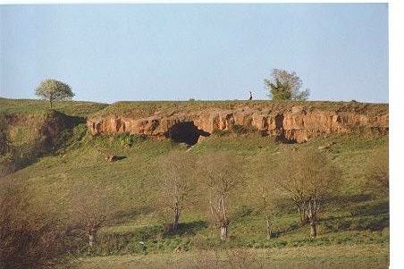
Pozzolana caves
(courtesy of Marco Placidi, c/o Roma sotterranea)
The most important river of the valley is the Almone, which originates at the foot of the Alban Hills and crosses the south-eastern area of the Roman countryside ("Campagna Romana") before reaching the Caffarella. Having crossed the valley it disappears near the Ancient Appian Way and joins the city's southern sewage system (whereas previously it joined the Tiber near the site of the present day gas works at Ostiense).
The two sides of the valley are between 300 and 500 m apart, suggesting morphological changes over time. It is believed, in fact that between 80 and 10 thousand years ago, during the Würm glaciation period, the river Almone eroded the vulcanic material and dug itself a canyon at a depth of almost 100 m; subsequently the river began depositing silt and sediments, filling the canyon and slowly eroding the banks which gradually separated to their present distance.
Of the dozen of springs that flow into the river Almone today, at least fifteen flow out directly into the valley from their subterranean source; the abundance of water in the area is due to the different permeability particular to vulcanic soils which also enriches the water, conferring it with mineral characteristics: the most notable example is that of the Acqua Santa spring, rich in carbon dioxide and with a slightly acidic taste.
The fertility of the soil, the abundance of water and the favourable climate have encouraged the growth of a rich and varied vegetation, as can be borne out by documents dating back from Roman times right up until the last century: thick woods interspersed with pasture land, water courses bordered by lush riverine vegetation, wetlands covered with typical marsh flora.
Little of this remains today. Man has modified the landscape to suit his agricultural needs, substituting the apparent disorganisation of nature with his orderly regulated fields. A few corners still remain almost untouched, however, a reminder of a now distant past, mingling with newly created environments, consequence of man's intervention.
With our backs to the Via Almone, on the left side of the valley, stand three small woods containing maples, holm oaks, pedunculate oaks and downy oaks, some of which are centuries old; on the opposite side of the valley there are two false acacia woods, whilst, at the far end. as well as a small concentration of poplars, stand long rows of southern nettle trees, mulberries and walnuts, reminders of man's influence on the landscape.

False acacia
On the higher ground dominating the Almone valley, the deep caves resulting from the occasional collapsing of sandstone quarries worked up until the end of the last century, have been colonised by a unique vegetation: elm, fig trees, Evonymous europaeus, dogwood, etc.
In a pond close to Via Almone, in between the giant reeds, the willows, the rushes and horsetails snipes and wagtails flit, frogs and toads leap and grass snakes and salamanders slither. In the more isolated woods, amidst the intricate undergrowth, made up mainly of butcher's broom, cornelian cherry, sloe, wild apple and wild pear, wild rose and alder, echo the calls and songs of sparrows, greenfinches, serins, great tits, blackcaps, blackbirds, robins, goldfinches, corn buntings or the sudden cry of the pheasant.

Butcher's broom
Up in the sky can be seen fan-tailed warblers, skylarks and kestrels; the latter is not the only predator in the vallew; foxes also live in the area. They are rarely seen, but their traces can be spotted due to the fact that they leave their droppings to mark their territory. Together with the kestrel and with nocturnal predators such as the little owl and the barn owl, they live amongst the main ruins and contribute to keeping the mouse and rat population under control. These rodents would otherwise thrive on the refuse which regularly gets tipped along the more accessible routes.

Kestrel
The Caffarella valley is today a typical example of "Campagna Romana" where history and nature live hand in hand with abandon and degradation; very different to the concern for the valley's welfare in ancient times. Suffice it to mention the traditions and legends linked to the ancient Roman cults which revered all natural phenomena and considered the woods, rivers and springs to be true divinities. As in the case of the Almone river which crosses the valley, and which the Romans identified with the divinity Almone, believed to distribute water aplenty or droughts at will.
His cult was important because it was situated at the gates of Rome and celebratory rites took place each year where the water of the small river flows into the Tiber: from the Palatine, where the temple of the Magna Mater (the goddess Cybeles) stood, a statue of the goddess would be carried with a solemn procession up to via Ostiense, where she and other objects of her cult would be washed in the water of the river Almone. Her's was a cult of oriental origin celebrated every year on 27 March. The ceremony lasted well into the III century A.D.
Along the banks of the river Almone, this time in the Caffarella Valley itself, during the "ides of July" each year Roman knights would ride in cavalcade in honour of Mars Gradivus, to commemorate the battle of Lake Regillus which took place in 493 B.C.
In ancient times other revered placed were the woods. Consular roads, at that time, would be bordered by thick "sacred woods". On the Caffarella, on a small hillock opposite the church of Sant'Urbano, three mediterranean oaks are the only survivors of what was once a vast wood where, as legend has it, the nymph Egeria, a minor ancient divinity linked to springs and childbirth, would meet with the king Numa Pompilius, and during their amorous encounters would advise him on new laws (in reality the sacred wood dedicated to Egeria was close to the Baths of Caracalla). The most beautiful and imposing sacred woods, the so-called "Luci", were protected by law and damage to them was punishable by death.

The sacred wood and the tomb of Cecilia Metella
Other legends are linked with the Caffarella, such as that of the god Rediculus (the god of safe return) protector of travellers, said to have appeared to Hannibal and his army as they were marching into Roma after the latter's victory at Cannae, frightening him and making him turn in his tracks.
As well these anecdotes the Caffarella has a rich and documentated history. The valley, in fact, which extends for 200 hectares outside the Roman city gate of San Sebastiano, because of its position between two of the most important roads in antiquity (the Ancient Appian Way and the Via Latina) has played an important role both historically and artistically, as well as culturally in the history of modern and ancient Rome.
The Via Latina is much older than the Via Appia: it is a natural road, already in use in prehistoric times, which originated, as did meny other roads, close to the Tiberina island and, after 191 km, reached Capua. During the III century B.C., after important engineering works had been carried out, the road was traightened; suffice it to think that the portion joining Rome to the hill town of Grottaferrata was a 15 km single straight line.
Today, apart from the stretch of road miraculously preserved in the Archaeological Park of Via Latina, little remains of this important ancient highway. Recent excavations in the Caffarella valley between Via di Vigna Fabbri and Via Cordara, in the place where the road overpassed with a great bridge the so-called Dell of Cessati Spiriti, have brought to light the remains of tombs and of the original ground of the road; another interesting tomb complex with niches and mosaics, brought to light in 1981 in Largo Nicomede Bianchi, was later covered over again when the modern Via Latina was tarmacked.

The sepulchre of Valerii in the Archaeological Park of Via Latina
The Appian Way, commissioned by censor Appius Claudius Caecus in 312 B.C., required a much greater engineering feat than that of the Latin Way; the Appian Way, in fact, by-passed the natural roads and headed straight for Capua, a forerunner of modern motorways.
More details:
|
At the beginning of Middle Age numerous towers were buildt both on Via Latina and on the Via Appia, to exact tolls from travellers using the roads. In order to avoid these tolls, alternative roads were created cutting through the adjacent countryside, roads which eventually increased in importance, supplanting their Roman precursor. The paved stretch of the Appian Way gradually fell into disrepair and was abandoned in favour of the Latin Way, which led to Capua anyway, or in favour of new roads as the Tuscolana, the casilina or the Appia Nuova (the New Appian Way).
Thus, the Caffarella valley, owing to its position at the gates of Rome and to the natural fertility of its soil, has for centuries been a site for cultivating fruit and vegetables. While able to import wheat and grain from afar, ancient Rome was forced to grow perishable foods closer to its walls; it was logical, therefore, to instal water cisterns in the valley (there are still traces of at least six) and to create large land holdings, such as that of Herodes Atticus.

Great cistern in front of S. Urbano
Herodes Atticus was a very rich and prominent figure of Imperial Rome who lived during the second century A.D., and was tutor to Emperors Lucius Verus and Marcus Aurelius.
Through his marriage to Annia Regilla, member of the famous Annii family abd descendant of Atilius Regulus, he came into ownership of a large estate, which had as its centre of activities the Villa, which was later transformed into the Palace of Maxentius on the opposite side of Via Appia Pignatelli.
Upon the death of his wife, Herodes Atticus was accused of murdering her but was was tried and acquitted, following which he gave great show of mourning her. In her honour, he redeveloped the estate and called it Triopius after Triopas, King of Thessaly, who had dedicated to Demeter, the goddess of harvests, a sanctuary in the city of Cnidus, in Asia Minor. Herodes also dedicated a temple to Ceres, the Roman goddess known as Demeter to the Greeks, and to Faustina a recently deceased empress which had been deified. By doing so, herodes wanted to raise his property above common mortal interests, and at the same time, by naming it after the King Triopas, protect it from theft or damage. Legend had that Triopas had to try and cut firewood in a forest sacred to Demeter, and as a punishment was condamned to suffer insatiable hunger eventually leading to his death.
The Triopius was an extremely rich property, extending up to the mausoleum of Cecilia Metella (on the Ancient Appian Way), the agricultural centre where the rural population lived.

The mausoleum of Cecilia Metella
(courtesy of Marco Placidi, c/o Roma sotterranea)
Meny epigraphs have come to light in the area, and together with the descriptions of ancient authors, provide us with an interesting insight into life in those days: wheat was cultivated as well as olive groves, vineyards, pasture land; there was also a police station, a sacred site dedicated to Nemesis and Minerva, a park, the colonial village and the residential villa; it was, therefore, an elegant sub-urban villa and a rich and industrious agricultural farm at the same time.
Today many historical remains have been found which bear witness to the richness of this estate. Among these are the afore-mentioned "Temple of Ceres and Faustina, which is still almost intact today thanks to its conversion in late antiquity into a Christian place of worship, thus ensuring its maintenance and preservation throughout the centuries.
The church was dedicated to Saint Urbano, a bishop martyred during the reign of Marcus Aurelius. A number of frescoes still decorate the interior and in the small crypt a madonna with child dating back to Tenth century can be admired.
At the foot of the hill on which Sant'Urbano stands, lies the so-called "Nymphaeum of Egeria", an artificial grotto adjacent a water source. Originally the cave was fronted by a portico and a pool formed by water coming from the spring. From here the water flowed into a vast lake into which the waters of the Almone also flowed, forming what was probably known as the Lacus Salutaris (the Lake of Health) mentioned in the chronicles of the time, due to the therapeutical properties of its mineral waters. The nymphaeum was also part of the Triopius and, with its sumptuous fountains, was a pleasant summer resting place.

The nymphaeum of Egeria
Not very far off, in the green valley between the Almone and Via della Caffarella, stands the so-called "Tomb of Annia Regilla", one of the most beautiful and well preserved monuments existing in Rome. Some experts believe this to be the tomb which Herodes Atticus dedicated to his wife, but it has come down to us as the Temple of God Rediculus (the god who made Hannibal return on his tracks by a terrible nightmare), which was in reality near the church of Domine Quo Vadis (on the Appian Way). Those walking through the valley or along its slopes, will surely notice many other ruins dating back to between the First and Fourth centuries A.D. (water cistern, villas, tombs), more or less distinguishable amidst the blackberry bushes and shrubs (not to mention the rubbish).
Also to be mentioned are the Jewish catacombs, those of Praetestatus and part of those of S. Sebastiano, which intertwine below ground on the side of the valley closest to the Appian Way.
Upon the death of Herodes Atticus the Triopius became imperial property and was progressively neglected. The barbaric ages were probably the darkest period for the Caffarella (excluding present day): set between via Appia and via Latina, it was right in the path of invading armies.
With the fall of Roman Empire and of its splendid palaces, villas and monuments, the countryside was abandoned and all the irrigation and drainage works soon fell into ruins through lack of maintenance, while nature began regaining hold.
In the ninth century the caffarella valley was known as the Vallis marmorea (Marble Valley) owing to the great number of marble remains to be found there. The marshy valley was separated into various holdings; at least five guard towers were erected along the river Almone, together with fortifications and military roadblocks along the via Appia and via Latina, which were then gradually abandoned as the via Appia Nuova (New Appian Way) and the via Casilina became increasingly important.

Guard - tower
Around the year 1000 the so-called "valche" or "mole" were also built, a kind of water-mill used for washing woollen clothes (= valche) or in the production of flour (= mole). A florid industry developed, especially in the case of the "valche", in later centuries protected by special "statutes" and by institution of privileges and tax exemptions.
In 1536 Emperor Charles the Fifth victouriously entered Rome through Porta S. Sebastiano; during this time that Caffarelli family, notable for having lavishly entertained the Emperor during his stay, bought the Almone Valley from various owners. The valley had by then become known by various names such as Marmorea, Vallis Apie, Aquataccio, Fontana Vergine, Acqua Santa etc.
This pleasant complex of valleys, woods and slopes, rich in ancient ruins, was restored by Giovanni Pietro Caffarelli to a fully functional agricultural farm; in 1547 he ordered the construction of the splendid "Vaccareccia", the central farm building which is still being used.
The valley was thus renamed after the Caffarelli family. Works were undertaken, stagnant waters were drained, the old canals deepened and new ones dug.
During that period the Caffarella also played a "hygienic" role: in 1656, when Rome was hit by the plageu, the mills in the valley were used for washing the infected laundry from the city (cloths, clothes, mattresses).
In 1695 the estate was sold to the Pallavicini family and later to the Torlonia family who at the beginning of the 19th century completely renovated the water system.
At that time the Caffarella more or less took on its current aspect and became an obligatory destination for weekend walks: in the last century and at the beginning of the present one there were numerous "osterie" or wine shops scattered within, the most well-known of which is brobably the one that stood inside the Nymphaeum of Egeria; chronicles of the time annoverate this place as a destination for important guests of Rome, underlining its beauty and value.
Today much has been lost, but all that has been cited so far is only a fraction of the great archaeological heritage still remaining. In its entirety the Caffarella Valley consitutes a unique historic and artistic picture, also because it is situated within the Campagna Romana, amidst oaks and pastures, and more importantly, adjacent to the Aurelian Walls, yet well within the current urban perimeter. It is obvious, therefore, why, since the '30s, it has been destinated to be a public park.
Unfortunately today, nonwithstanding the insitution of the regional Park of the Appia Antica, the Caffarella had been a "no man's land" up to the end of the 20-th century. During many scores the owners (among whom is the Gerini Foundation, which has inherited all the property once belonging to the Torlonia), because of petty binding laws have been unable to exploit tha land and, due also to complete lack of interest on the part of public authorities, had abandoned it for a number of years to filth and degradation.
The agricultural situation, dating back to the 19th century structure, has been drastically modified, partly due to the complete lack of interest on the part of its owners, and partly to the ever-increasing phenomenon of illegal cultivation, whereby allotments are formed. The valley, since time immemorial always used as grazing land, has been spoilt by dumping of spent loam from the numerous illegal mushroom farms scattered in the caves in the area and by the intrusion of a sewage system that crosses the entire valley.
The "sacred" river Almone has become an open sewer.
Ancient ruins, tombs and water cisterns were used as barns or stores. Not to mention the more beautiful monuments (the tomb of Annia Regilla and the church of S. Urbano), which have been literally impounded and incorporated into private villas and protected by electric fences and guard dogs. The green fields were ruined by motorbyke tracks, ancient trees and entired woods were cut down for firewood or to enlarge the illegal allotments.
Yet in spite of all this, the Italian Government and the town of Rome succeeded in restoring at least half of the valley, in occasion of the great Jubilee of the year 2000. 20 millions Euro were spent to buy the land and to restore the monuments. The church dedicated to Sant'Urbano, the Nymphaeum of Egeria, the Temple so called of the God Rediculus, the guard tower are opened on Sundays for free guided tours by the volunteers of the local association. Then, the Caffarella can still be considered as the typical example of the Roman campagna, with its remaining pockets of spontaneous vegetation merging with agricultural activity and with the historic and archaeological remains.
Guided tours and other activities provided by the Comitato per il Parco della Caffarella |
In this short note we wanted only to mention some of the characteristics of the Caffarella Valley; to deepen various aspects we suggest to look into the references, with some HTML texts as well book and article references.
For any comment and observation you can contact us via e-mail c/o:
comitato@caffarella.it
Text translated by Teresa Borelli and up to dated by Mario Leigheb
To come back to the home page:
Notizie sul Municipio Roma IX, Caffarella, Appia Antica e Tang. Est